In the following table the higher-level products which have been defined in the frame of the geosphere research topic are listed. These products can be only derived from Tandem-L image data recorded in the “Deformation Mode”. Tandem-L will record all tectonic active regions worldwide up to 3 times per cycle (16 days). This high repetition rate is necessary in order to achieve the accuracy of the products. Concerning the user interest, most of the respondents (29) were interested in “Small Scale Deformation” products. In comparison, the user interest regarding the “Global Strain Rate Map” (11) is quite low. This can possibly be explained by the long waiting period which is indicated with 10 years.
| Product | Scale | Spatial Resolution | Accuracy | Temporal Resolution |
|---|---|---|---|---|
| Global Strain Rate Map | Global | 50 m x 50 m | < 3 x 10e-9 [1/y] | At the end of the mission (after 10 years) |
| Large Scale Deformation (3D Deformation Rate Map) Interseismic | All critical areas | 50 m x 50 m | 1 mm/y/350 km for East and vertical components (after 10 years) < 10 mm/y for North components | yearly |
| Earthquake Event | Local | 50 m x 50 m | 10 mm | on demand |
| Long Term Volcanic Deformations | 1530 largest volcanoes | 50 m x 50 m | 10 mm/month | yearly |
| Volcanic Activity | Local | 50 m x 50 m | 5 mm | on demand |
| Landslides | Selected areas | - | 5 - 10 mm/year | weekly |
| Urban subsidence | Selected areas | - | 5 - 10 mm/year | monthly |
The conformance of the listed product specifications with the user requirements is shown in the following figure. It can be observed that the majority of respondents were satisfied with the stated specifications of most products. Only in case of the “Volcanoes” products and the "Large Deformation Rate Map", several users are dissatisfied with some product specifications. In terms of the “Volcanoes” products, a number of respondents were asking for a better spatial resolution. For this purpose it can be stated that currently a spatial resolution of 10 m x 10 m is planned for the "Volcanic Activity" product which covers the whole activity period of the corresponding volcanoes. However, in case of the “Long Term Volcanic Deformation” product no further adjustments are intended.

Conformance of the user requirements with the product specifications (Spatial Resolution, Accuracy, and Temporal Resolution) for the geosphere products.
Concerning the “Large Scale Deformation” product, various users were asking for a better temporal resolution; a quarterly or even monthly period was demanded. However, such an increase of the product generation interval would adversely affect the product accuracy. Currently, the Tandem-L product implementation team is considering a more frequent product delivery at the expense of reduced accuracy.
Beside the temporal resolution, several users were asking: “How will the three components (North, East and vertical) of the “Large Scale Deformation” product be derived from 2D observations. Will there be additional observation geometries, e.g. high squint?” Here can be stated, that currently all three components will be generated by performing periodical acquisition campaigns in left looking.
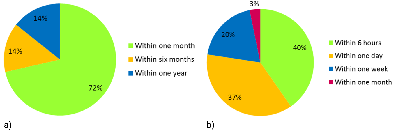
Indicated time frame for the product availability after image acquisition for a) geo risk monitoring products (Large Scale Deformation, Long Term Volcanic Deformations) and b) geo hazards products (Volcanic Activity, Earthquake Event, Landslides and Urban Subsidence)
The figure above shows the required availability of the geosphere products. As expected, there is a significant difference between the products that support the geo risk monitoring (Global Strain Rate Map, Large Scale Deformation and Long Term Volcanic Deformations) respectively the geo hazard products (Earthquake Event, Volcanic Activity and Small Scale Deformations). Approximately 40% of the respondents require the geo hazard products within six hours and still 37% within one day. Unfortunately, such a fast product generation is, due to performance reasons, not possible. The goal is to provide maps with reduced accuracy within 48 hours after the acquisition of all images required for the product generation. Maps with the specified accuracy shall be available within 20 days.