Six higher-level image products were defined in the frame of the Biosphere research topic. It should first be explained that the proposed Tandem-L satellite mission will operate in two complementary measurement modes; the “Deformation Mode” and the “3D Structure Mode”. The specified biosphere products can only be produced with satellite image data that were recorded in the “3D Structure Mode”.
For every product concrete product specifications were determined (see following table), mirroring the performance of the Tandem-L mission and the developed processing chains. Within the questionnaire, the users compared their requirements with these product specifications. In total, of the 101 respondents who took part in the survey, 41 were interested in biomass products, 37 in forest structure products and 31 in the upper canopy height products.
| Product | Scale | Spatial Resolution | Accuracy | Temporal Resolution |
|---|---|---|---|---|
| Upper Canopy Height | Global | 50m x 50m | 20% | 6 months |
| Regional | 30m x 30m | 20% | yearly | |
| Upper Canopy Height Change | Global | 50m x 50m | 1 m to 30% of the change | yearly |
| Regional | 30m x 30m | 1 m to 30% of the change | on request | |
| Forest Structure | Global | 50m x 50m x 10m | 20% (20 t/ha for biomass < 100 t/ha) | 6 months |
| Regional | 30m x 30m x 5m | 20% (20 t/ha for biomass < 100 t/ha) | yearly | |
| Forest Structure Change | Global | 50m x 50m x 10m | 30% for changes larger than 50 t/ha per layer | yearly |
| Regional | 30m x 30m x 5m | 15% for changes larger than 50 t/ha per layer | on request | |
| Above Ground Biomass | Global | 100m x 100m | > 20 t/ha or 30% | 6 months |
| Regional | 50m x 50m | 10-15 t/ha or < 20% | yearly | |
| Above Ground Biomass Change | Global | 100m x 100m | 5 t/ha to 30% of the change | yearly |
| Regional | 50m x 50m | 5 t/ha to 30% of the change | on request |
The following figure shows the conformance of the product specifications with the user requirements. It can be observed, that more than 50% of the respondents are satisfied with the listed product specifications. Between 15% and 45% of the interviewees were undecided with regard to the specifications or did not answered to the questions.
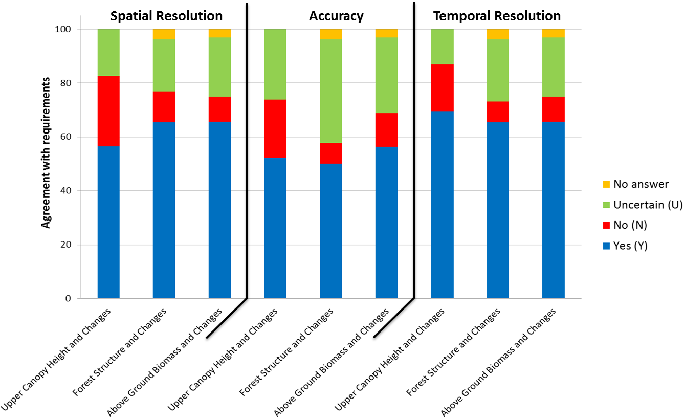
Conformance of the user requirements with the product specifications (Spatial Resolution, Accuracy, and Temporal Resolution) for the biosphere products.
In the case of the “Upper Canopy Height and Change” products approximately 25% of the users were asking for a better spatial resolution and a higher accuracy. While, due to performance reasons of Tandem-L, the products cannot be generated with a higher spatial resolution, in most cases an accuracy of up to 10% can be achieved on both global and regional scale. The high uncertainty of the users regarding the accuracy of the “Forest Structure and Change” products can be explained by the lack of a standard definition of forest structure. In the user community different definitions of forest structure address different applications and/or characteristics of structure. The “Forest Structure” product provided by Tandem-L is defined as a 3D map (matrix) of the vertical distribution of biomass (in t/ha) with a given vertical resolution estimated from the 3D radar reflectivity. In addition, many users have little or no experience with derived remote sensing products, they cannot estimate whether this product is consistent with their understanding of the forest structure. In this case further analyzes are necessary.
Concerning the data availability after image acquisition, most of the respondents were satisfied to get the requested forestry products within one month. In case of a disturbance caused by a storm or fire event, a considerable number of foresters have spoken out for immediate image acquisitions and rapid product deliveries. The emergency scenario of Tandem-L stipulates rapid image acquisitions in the corresponding acquisition mode. This means that when Tandem-L is recording image data in the “Deformation Mode”, this mode is not changed at short notice and also no higher-level products are derived from these image data. Certain disturbances in the forest can be detected based on change detection algorithms. However, for the estimation of structural and biomass changes images of the “3D Structure Mode” are necessary.
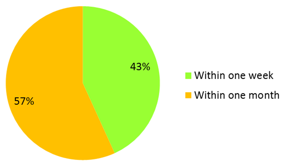
Indicated time frame for the biosphere product availability after image acquisition