The majority of EDA products were defined in the cryosphere research topic. As can be seen in the following table, these products support land ice, sea ice and permafrost applications. Unfortunately, the resonance of the sea ice and permafrost products was not very high in the questionnaire. 12 people answered the questions about sea ice products and 13 about the permafrost products. The reason for the rather low interest could be explained by the fact that the users of such products were significantly underrepresented in the user group who received the questionnaire. In order to be able to make representative statements concerning the user requirements, consequently further discussions are doubtless necessary.
| Product | Scale | Spatial Resolution | Accuracy | Temporal Resolution |
|---|---|---|---|---|
| Grounding Line Position | Antarctic and ice tongues in Greenland | 30 m x 30 m | 30 m | seasonal - yearly (3 - 5 consecutive observations) |
| Elevation Change | All ice sheets, ice caps and glaciers | 50 m x 50 m | 10% of the change | 6 months |
| Glacier Velocity | All glaciers | 50 m x 50 m (small glaciers) 500 m x 500 m | 10% - 20% (for glaciers <5 - 50 m/y) | weekly |
| Land Ice Structure | All ice sheets, ice caps and glaciers | 100 m x 100 m | separation of several layers | yearly |
| Sea Ice Extent and Concentration | Arctic and Antarctic Sea | 1 km x 1 km 50 km x 50 km | 10% | seasonal |
| Sea Ice Type | Arctic and Antarctic sea | 50 m x 50 m | 5% - 20% | monthly |
| Sea Ice Drift | Arctic and Antarctic sea | 50 m x 50 m | 1 m/s | weekly |
| Regional Permafrost Extent | Permafrost areas | 80 m x 80 m | 50 m | after 10 years |
| Ground Freeze/Thaw | Selected critical areas | 40 m x 40 m 80 m x 80 m | 50 m | weekly |
| Thaw-Season Subsidence | Selected critical areas | 40 m x 40 m 80 m x 80 m | 50 mm/year | seasonal |
On the other hand, 23 respondents were interested in the land ice products. The next figure shows the conformance of the product specifications with the user requirements. It can be observed that most of the respondents were satisfied with the indicated product specifications. In case of the “Glacier Velocity” product several users were asking for a better spatial resolution. Here can be stated, due to the present algorithms no adjustment can currently be promised for small-scale glaciers. However for large-scale glaciers a spatial resolution of 200 m can be achieved.
Furthermore, some respondents were asking for a better temporal resolution of the “Elevation Change” product. They required this product on a monthly or seasonal basis. In case of the Arctic region and all glaciers worldwide a higher latency may be possible; however, due to the inclination of the Tandem-L satellites a faster update of the Antarctica is not possible. For this region image data have to be acquired in left looking mode and such special acquisition campaigns are only planned periodically.
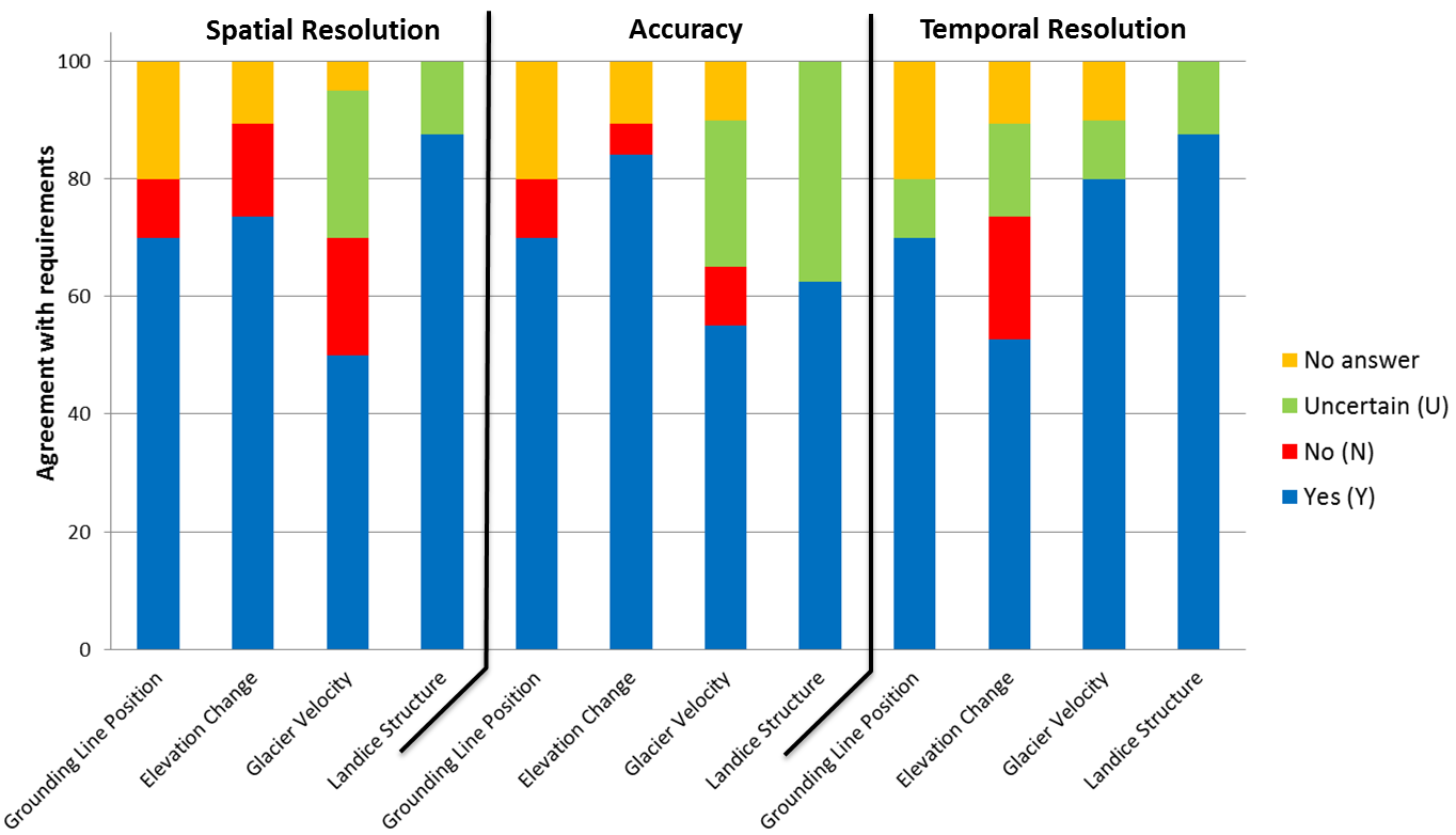
Conformance of the user requirements with the product specifications (Spatial Resolution, Accuracy, and Temporal Resolution) for the land ice products.
The following figure shows the conformance of the user requirements with the coresponding product specifications for the sea ice and permafrost products. As can be seen, most of the user complaints were directed against the temporal resolution of these products. In case of the sea ice products serveral respondents asked for a daily product generation intervall. Such a fast repetition rate is not possible. However, for the “Sea Ice Extent and Concentration” as well as the “Sea Ice Type” product the latency was decreased with the goal of a 14-days update.
Concerning the permafrost products, the majority of the respondents were interested in the “Regional Permafrost Extend” (13 responds) product closely followed by the “Ground Freeze/Thaw” (12 responds) product. Only six users answered the questions about “Thaw-season Subsidence” product. Approximately one quarter of the prospective customers of the “Regional Permafrost Extent” product require an one to five years update of the maps. Here further discussions are necessary. However, such an increase of the mapping interval would certainly adversely affect the specified product accuracy.
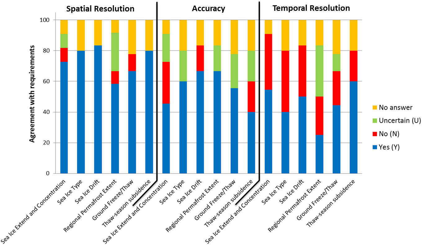
Conformance of the user requirements with the product specifications (Spatial Resolution, Accuracy, and Temporal Resolution) for the sea ice and permafrost products.