In addition to the products defined in the scope of the EDA Alliance, users within the questionnaire were also consulted about their interest in a “Digital Elevation Model” (DEM). In the course of the Tandem-L mission, the generation of global DEM’s is planned as is specified below on a yearly basis.
Tandem-L DEM Specifications
The Digital Elevation Model is a Digital Surface Model (DSM) and a 3D-map of the surface height of natural terrain features in addition to vegetation and man-made features such as buildings and roads. The surface model will be generated based on bistatic L-band interferometric SAR acquisitions with across-track baselines between 100 m and 500 m.
| Product | Scale | Spatial Resolution | Absolute Horizontal Accuracy | Absolute Vertical Accuracy | Relative Vertical Accuracy | Temporal Resolution |
|---|---|---|---|---|---|---|
| Digital Surface Model | Global | 12 m x 12 m | < 10 m | < 10 m | 2 m (slope <=20%) 4 m (slope > 20%) | yearly |
The target Tandem-L DEM specifications are in the same order than the corresponding TanDEM-X DEM specifications (see Table 12). For ice- and snow-covered areas as well as sandy deserts the relative and absolute height accuracy will be relaxed, due to the stronger penetration capabilities in L-band. However, for vegetation areas a better accuracy can be expected than is specified in the table.
Over half of the respondents in the questionnaire were interested in the proposed DSM (57 responds). As can be observed in the figure the product specifications meet in the most cases the requirements of the prospective customers. The yearly update of the global DSM is for the majority of the users also adequate. However, in order to meet the requirements of elevation change observations (e.g. alpine glaciers, volcanoes etc.) local DSM’s will be generated with more flexible and frequently (e.g. seasonal, on demand) updates.
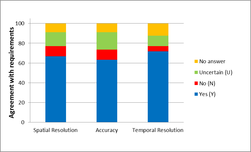
Conformance of the user requirements with the corresponding DSM product specifications.