In the course of the questionnaire the respondents were also asked if they are interested in basic radar image products. These are operational Tandem-L products offered to scientific and commercial customers. With respect to the geometric projection and data representation, Tandem-L basic image products will be differentiated into following four product types:
Single Look Slant Range Complex (SSC): This product is the basic single look product of the focused radar signal. The pixels are spaced equidistant in azimuth according to the pulse repetition interval PRI=1/PRF and in slant range according to the range sampling frequency. The data are represented as complex numbers containing amplitude and phase information. Each image pixel is processed to zero Doppler coordinates in range direction, i.e. perpendicular to the flight track. The product is compatible with the standard slant range products available from TerraSAR-X and TanDEM-X.
Multi Look Ground Range Detected (MGD): This product is a detected multi look product with reduced speckle and approximately square resolution cells. The image coordinates are oriented along flight direction and along ground range. The pixel spacing is equidistant in azimuth and in ground range. For the slant to ground range projection the WGS84 ellipsoid and an average, constant terrain height value are used. The MGD corresponds to the TerraSAR-X and TanDEM-X product.
Geocoded Ellipsoid Corrected (GEC): The GEC product is a multi-look detected product, which is resampled and projected to the WGS84 reference ellipsoid assuming one average height. The image is represented in map geometry with ellipsoidal corrections only, thus no terrain correction is performed. Available grid formats are UTM (Universal Transversal Mercator) and UPS (Universal Polar Stereographic). The GEC corresponds to the TerraSAR-X and TanDEM-X product.
Enhanced Ellipsoid Corrected (EEC): The EEC product is a multi-look detected product as well, projected and resampled to the WGS84 reference ellipsoid. However, image distortions caused by varying terrain height are corrected using an external Digital Elevation Model (DEM). The image is represented in map geometry with terrain correction. The available map projections are UTM or UPS. The EEC corresponds to the TerraSAR-X and TanDEM-X product.
In total, 71% of the respondents were interested in the proposed basic radar image products. The remaining ones were not interested or did not complete the corresponding question. The distribution of the respondents concerning the special basic radar image types is shown in the following figure. As can be observed, approximately half of the users were interested in the Single Look Slant Range Complex image product. The other half is spread over the other three image products.
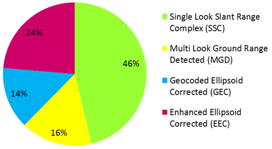
Distribution of the prospective customers on basic radar image products